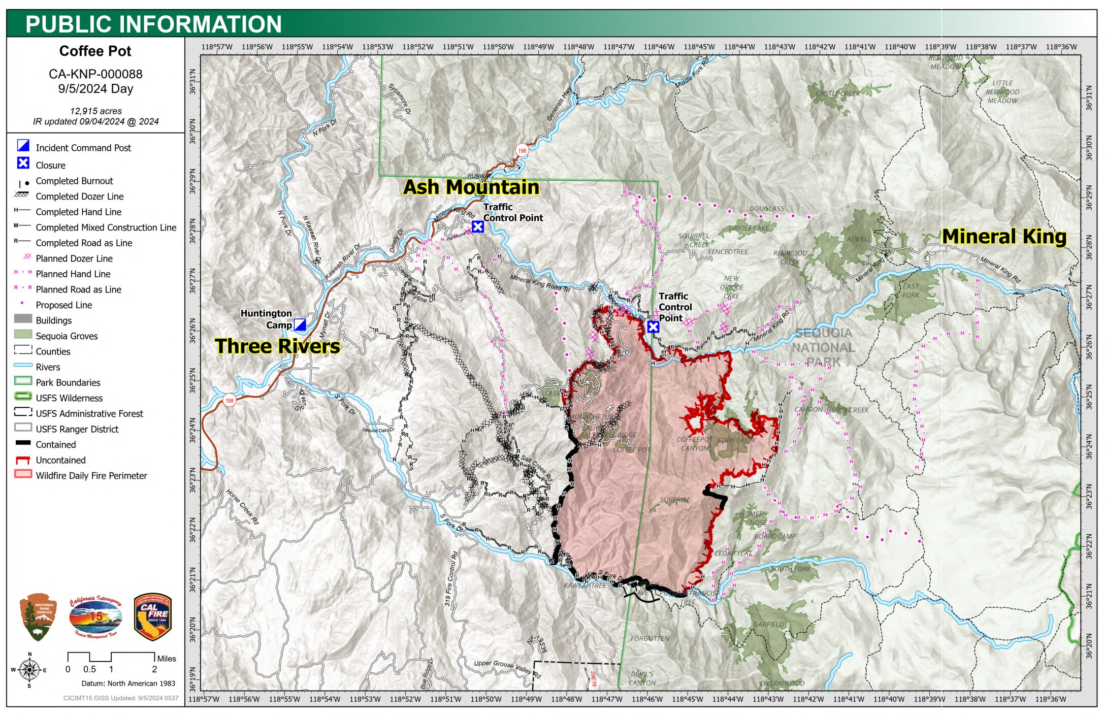
The Coffeepot Fire is 13,041 acres with 25% Containment
- Size: 13,041 acres
- Cause: Lightning
- Email: 2024.coffeepot.ca@firenet.gov
- Incident Website: inciweb.wildfire.gov/incident-information/caknp coffeepot-fire
- Start Date: Monday, August 3, 2024, at 10:05 AM
- Percent Contained: 25%
- Personnel: 1341
CONTENT PROVIDED BY INCIDENT MANAGEMENT TEAM
NOTE: We have edited the content to exclude information that is pertinent to social media users only. Additions by the Three Rivers Together team are in brackets.
CURRENT SITUATION: Yesterday morning, crews patrolled the Northeast area as a low-intensity fire backed down from Eden Creek Grove, but as the inversion lifted in the early afternoon, fire activity increased. Terrain-driven winds caused the fire to cross Eden Creek, but these fires remained within planned control lines. Firefighters were inserted to strengthen and improve handlines. To the South, firefighters worked to strengthen containment lines along South Fork Drive. Crews mopped up fire that extended beyond the direct control lines east of Scratch Creek. Along the north flank, crews mopped up where fire crossed the river near Lookout Point. Retardant was used to lower the risk of the fire moving beyond direct control lines.
Today, firefighters will work to improve control lines where the fire crossed Eden Creek. Air operations will continue to enhance suppression efforts. As the fire’s western side becomes controlled, firefighters will pivot their efforts towards the eastern flank to support operations. Crews will continue to backhaul water tanks, hoses, and equipment along the south flank and also continue road repair and removal of hazardous trees. Road improvements along Salt Creek Road are ongoing. Crews will mop-up the spot where fire crossed the East Fork Kaweah River near Lookout Point. Water tenders continue to use retardant along Mineral King Road to reduce the risk of the fire moving beyond this contingency control line.
WEATHER: Temperatures will remain well above average. Thunderstorm chances are expected to be limited to the Sierra Crest. General winds remain from the southwest, while up-canyon winds are expected to develop mid-morning.
SMOKE IMPACTS: Three Rivers and Hammond will continue to see the main smoke impacts. Levels will reach UNHEALTHY FOR SENSITIVE GROUPS in the morning before improving to MODERATE during the afternoon and evening. The Giant Forest will likely see the highest concentrations later in the day, reaching UNHEALTHY FOR SENSITIVE GROUPS. Communities as far north as Oakhurst and east toward Independence and Bishop will continue to see MODERATE levels at times, averaging GOOD today and tonight. The Boone fire will continue contributing light smoke to the San Joaquin Valley. For more information on current wildfire smoke impacts in your community, please visit AirNow.gov or fire.airnow.gov. [NOTE FROM THREE RIVERS TOGETHER: For additional information on the air quality in Three Rivers locations, visit Purple Air. A monitor has recently been installed on South Fork.]
EVACUATION NOTICES: The Tulare County Sheriff’s Office has issued Evacuation ORDERS due to current fire conditions for Genasys zones TLC-E094-C, TLC-E094-E, TLC-E094-D, and TLC-E094-B. An evacuation ORDER, also known as a mandatory evacuation, means that all residents and visitors should leave now before the fire reaches the community. If you are unable to evacuate and require assistance, please call 9-1-1. In case of sheltering needs or questions regarding sheltering, please contact the American Red Cross at 1-800-733-2767.
The Tulare County Fire Department has also issued Evacuation WARNINGS for zones TLC-E128-B, TLC-E093-A, TLC-E093-B, TLC-E095, TLC-E127-B, and TLC-E128-A. To find your zone, please refer to: protect.genasys.com.
[NOTE FROM THREE RIVERS TOGETHER: Because people have found the Genasys map challenging, the Three Rivers Together team has been creating a map that includes the community boundaries, structures, and familiar landmarks. To view this map, go to https://3rtogether.org/map/.]
FIRE INFORMATION: A Public Information Officer will be at the Three Rivers Village Market daily from 10:30 AM to 4:00 PM to provide fire information and answer questions.
BLM AND PARK CLOSURES: The portion of South Fork Drive in Sequoia National Park and trails accessed from the road, including the Lady Bug and Garfield Grove Trails, are closed until further notice. You can view all Park closure information online at nps.gov/seki . The Bureau of Land Management has also issued a closure of the Case Mountain Extensive Recreation Management Area at blm.gov/press-release.
PUBLIC NOTICE: Wildfires are a no-fly zone for unauthorized aircraft, including drones. If you fly, we can’t. For more information, visit knowbeforeyoufly.org.