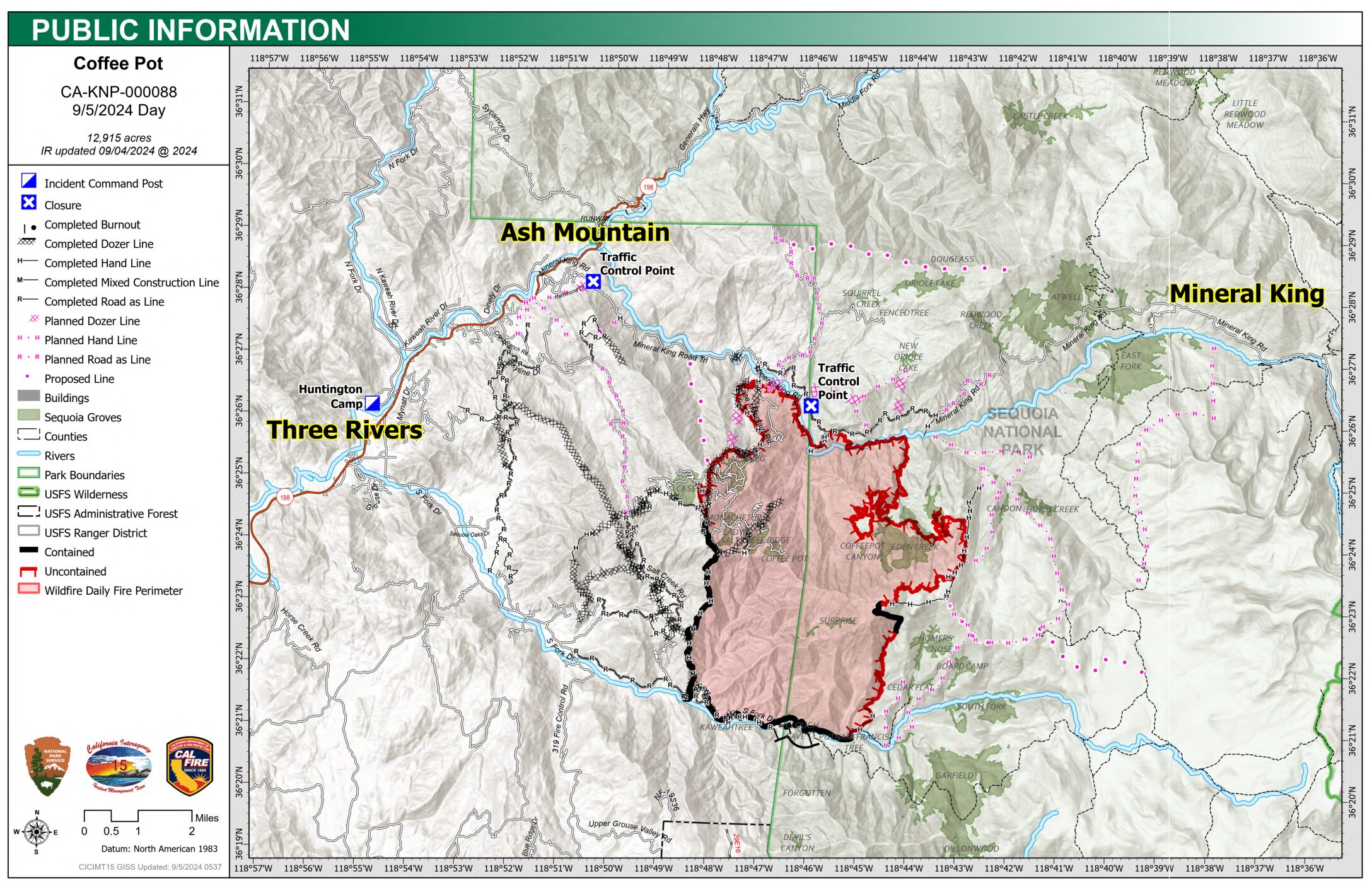
The Coffeepot Fire is 12,915 acres with 23% Containment
- Size: 12,915 acres
- Cause: Lightning
- Email: 2024.coffeepot.ca@firenet.gov
- Incident Website: inciweb.wildfire.gov/incident-information/caknp coffeepot-fire
- Start Date: Monday, August 3, 2024, at 10:05 AM
- Percent Contained: 23%
- Personnel: 1522
CONTENT PROVIDED BY INCIDENT MANAGEMENT TEAM
NOTE: We have edited the content to exclude information that is pertinent to social media users only. Additions by the Three Rivers Together team are in brackets.
CURRENT SITUATION: Yesterday, firefighters prioritized operations on the fire’s northern flank. Crews enhanced direct control lines along the East Fork Kaweah River while tactical water tenders applied retardant along Mineral King Road. Using tactical water tenders allow aviation support to concentrate on other areas. All spot fires along the northern flank were identified, contained, and extinguished. Moving east along the Kaweah River, firefighters patrolled the fire as it slowly backed down toward the river. In coordination with crews on the ground, drones conducted aerial ignition operations to produce low-intensity fire to moderate the effects around the giant sequoia groves near Eden Creek. Heavy equipment was used to continue road and trail repair to the south. Mop-up operations continued along the southern flank of the fire.
Today, crews will focus on reinforcing direct control lines in the north. Aircraft, in conjunction with crews on the ground, will slow the progression and intensity of the fire. In the south, crews will continue to improve control lines along South Fork Drive and Salt Creek Road. Firefighters will continue to mop-up and mitigate hazardous trees in contained fire areas.
WEATHER: High pressure will remain over the area, keeping conditions hot and dry. Winds today will shift from the overnight drainage to upslope in the morning and stay through the afternoon. With high pressure overhead, the inversion may break later in the morning, trapping smoke in the valleys into the early afternoon, especially in sheltered areas. Skies will remain mostly sunny, with a few clouds over the Sierra Crest.
SMOKE IMPACTS: Three Rivers, Hammond, and Springville will experience the most smoke impacts this morning, with levels reaching UNHEALTHY FOR SENSITIVE GROUPS to UNHEALTHY before improving to MODERATE during the afternoon and evening. The Giant Forest will likely see the highest concentrations during the afternoon and evening, reaching UNHEALTHY at times. Communities as far north as Oakhurst may see levels increase to MODERATE through the day into tonight. For more information on current wildfire smoke impacts in your community, please visit AirNow.gov or fire.airnow.gov. [NOTE FROM THREE RIVERS TOGETHER: For additional information on the air quality in Three Rivers locations, visit Purple Air. A monitor has recently been installed on South Fork.]
EVACUATION NOTICES: The Tulare County Sheriff’s Office has issued Evacuation ORDERS due to current fire conditions for Genasys zones TLC-E094-C, TLC-E094-E, TLC-E094-D, and TLC-E094-B. An evacuation ORDER, also known as a mandatory evacuation, means that all residents and visitors should leave now before the fire reaches the community. If you are unable to evacuate and require assistance, please call 9-1-1. In case of sheltering needs or questions regarding sheltering, please contact the American Red Cross at 1-800-733-2767.
The Tulare County Fire Department has also issued Evacuation WARNINGS for zones TLC-E128-B, TLC-E093-A, TLC-E093-B, TLC-E095, TLC-E127-B, and TLC-E128-A. To find your zone, please refer to: protect.genasys.com.
[NOTE FROM THREE RIVERS TOGETHER: Because people have found the Genasys map challenging, the Three Rivers Together team has been creating a map that includes the community boundaries, structures, and familiar landmarks. To view this map, go to https://3rtogether.org/map/.]
FIRE INFORMATION: A Public Information Officer will be at the Three Rivers Village Market daily from 10:30 AM to 4:00 PM to provide fire information and answer questions.
BLM AND PARK CLOSURES: The portion of South Fork Drive in Sequoia National Park and trails accessed from the road, including the Lady Bug and Garfield Grove Trails, are closed until further notice. You can view all Park closure information online at nps.gov/seki . The Bureau of Land Management has also issued a closure of the Case Mountain Extensive Recreation Management Area at blm.gov/press-release.
PUBLIC NOTICE: Wildfires are a no-fly zone for unauthorized aircraft, including drones. If you fly, we can’t. For more information, visit knowbeforeyoufly.org.