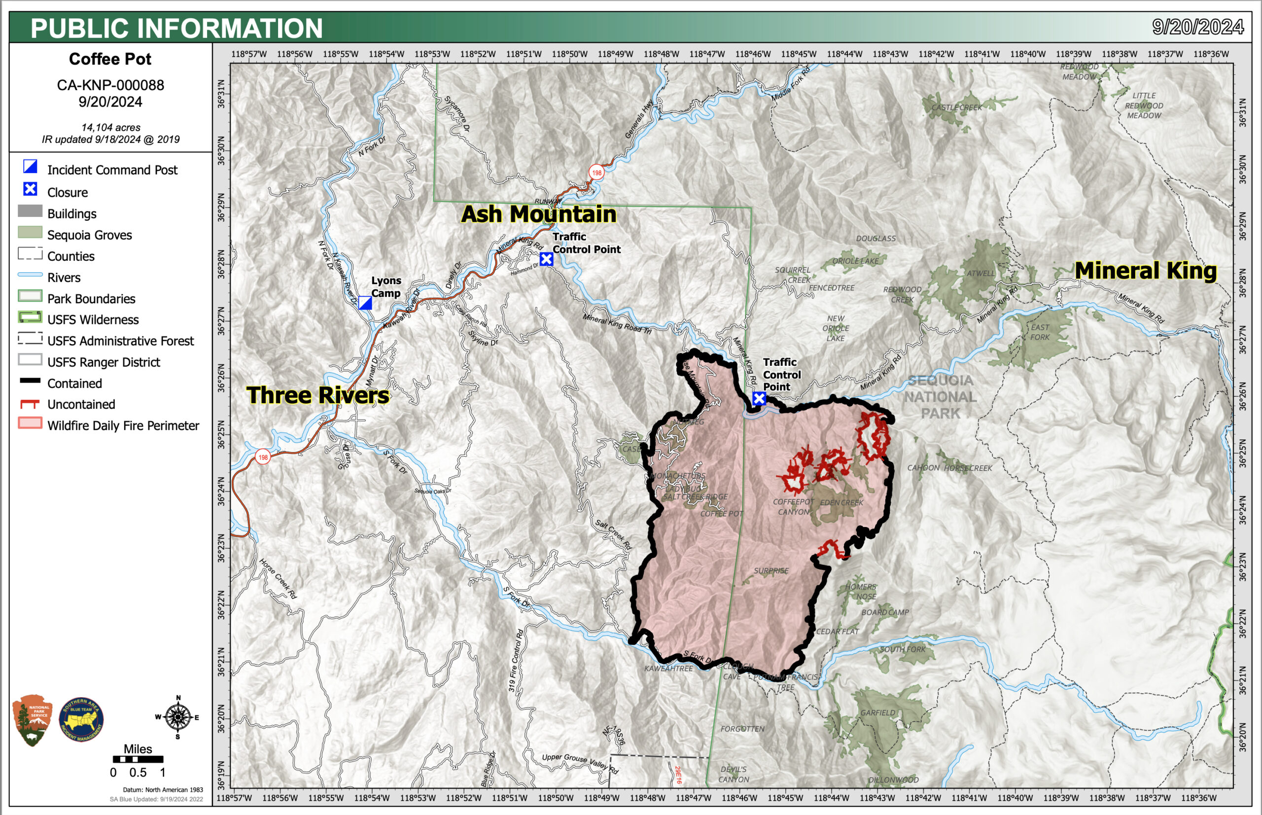
The Coffeepot Fire is 14,104 acres with 93% Containment
- Size: 14,104acres
- Cause: Lightning
- Email: 2024.coffeepot.ca@firenet.gov
- Incident Website: inciweb.wildfire.gov/incident-information/caknp coffeepot-fire
- Start Date: Monday, August 3, 2024, at 10:05 AM
- Percent Contained: 93%
- Personnel: 316
CONTENT PROVIDED BY INCIDENT MANAGEMENT TEAM
NOTE: We have edited the content to exclude information that is pertinent to social media users only. Additions by the Three Rivers Together team are in brackets.
This is the final daily update for the Coffee Pot Fire. The Sequoia and Kings Canyon National Parks will release information if fire conditions change.
CURRENT SITUATION: The Southern Area Blue Team will transition to the local Type 3 Incident Management Team at 0700, on Saturday September 21, 2024. Firefighters will continue to monitor containment lines on all perimeters of the fire with special emphasis along Mineral King Road and the Horse Creek drainage area. Engines and firefighters will remain present in the Horse Creek / Mineral King Road area to ensure the fire remains within the current footprint and are able to respond to increase fire behavior, if needed. Suppression equipment continues to be backhauled from areas of the fire where no longer needed.
WEATHER: Following Thursday’s unsettled weather pattern that resulted in temporary cooler and wetter conditions, a gradual warming and drying trend will begin on Friday. This warming will increase temperatures to 50-70 degrees over the fire elevations with relative humidity of 40-50%. Sustained west-southwest winds will reach 3-7 mph with gusts of 10-15.
SMOKE IMPACTS: Today is the last forecast for smoke related to the Coffee Pot Fire. Haze around the fire will be visible during the day. Expect GOOD air quality with some hours of MODERATE in areas closest to the fire. For more information on current wildfire smoke impacts in your community, please visit AirNow.gov or fire.airnow.gov.
[NOTE FROM THREE RIVERS TOGETHER: For additional information on the air quality in Three Rivers locations, visit Purple Air. A monitor has recently been installed on South Fork.]
EVACUATION NOTICES: The Tulare County Fire Department continues to have an Evacuation WARNING in place for zone TLC-E095. To find your zone, please refer to: protect.genasys.com. [NOTE FROM THREE RIVERS TOGETHER: Because people have found the Genasys map challenging, the Three Rivers Together team has created a map that includes the community boundaries, structures, and familiar landmarks. To view this map, go to https://3rtogether.org/map/.]
BLM AND PARK CLOSURES: The portion of South Fork Drive in Sequoia National Park and trails accessed from the road, including the Lady Bug and Garfield Grove Trails, are closed until further notice. You can view all Park closure information online at nps.gov/seki . The Bureau of Land Management has also issued a closure of the Case Mountain Extensive Recreation Management Area at blm.gov/press-release.
PUBLIC NOTICE: Wildfires are a no-fly zone for unauthorized aircraft, including drones. If you fly, we can’t. For more information, visit knowbeforeyoufly.org.